Key Takeaway
“Key risk for hull underwriters: The territorial-water band sits outside the Listed Area but is now where a growing share of Black Sea tonnage spends its time. The exposure is therefore concentrating in the part of the basin where the JWC mechanism gives underwriters no notification, no additional premium and no indication of how many insured hulls are present”.
Executive Summary
How JWLA-035 Is Reshaping Black Sea Shipping Routes and Risk Exposure
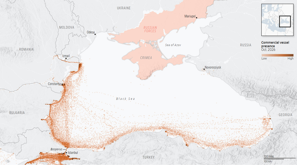
- Since the Joint War Committee (JWC) extended the Black Sea Listed Area on 16 September (JWLA-035), Ambrey has observed a significant increase in the number of vessels sailing through the territorial waters of Türkiye, Bulgaria and Romania
- JWLA-035 lists the whole Black Sea except the territorial waters of Türkiye, Bulgaria, Romania and Georgia. Vessels use those waters to avoid the Listed Area, and because targeting has largely taken place outside the territorial waters of the Black Sea’s non-belligerent states
- Hull underwriters: the exposure is building in the one part of the basin that generates no notification, no additional premium and no signal of how much tonnage is present
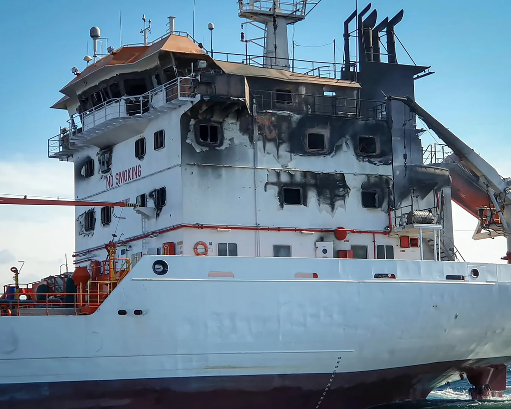
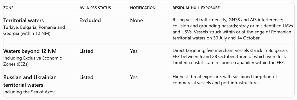
- Territorial waters are not a sanctuary: a merchant vessel was struck 8.1 NM southeast of Sulina, within Romanian territorial waters, on 30 July, and a tanker was struck at Sulina Anchorage on 14 October. In Bulgaria’s Exclusive Economic Zone (EEZ), two merchant vessels were struck on each of 6 and 13 October, one lost each time, and a container ship was sunk by USVs on 28 October
- Vessels have been struck in Turkish and Romanian territorial waters in 2026, including a tanker 11.6 NM north of the Bosphorus (25 March) and a general cargo ship 10 NM off Giresun (11 October).
- Bulgarian officials have stated that legal restrictions prevent Bulgaria from acting against UAVs outside its territorial waters, leaving the zone immediately beyond the corridor with little coastal-state response capacity
- GNSS and AIS interference, a narrow corridor and shared fishing and leisure traffic add a navigational threat; it is a realistic possibility that a collision, grounding or close-quarters incident involving a merchant vessel will occur in the corridor in the next six months
- Should a significant event occur in Bulgarian, Georgian, Romanian or Turkish waters, it is likely that the coastal states will review their current openness to transit and be more assertive over which vessels may pass through their territorial waters and subject the vessels to inspections
- It is likely that traffic will remain concentrated in the territorial waters for as long as JWLA-035 stands
SITuATION
Expansion of the JWC Listed Area and Its Impact on Commercial Vessel Routing
On 16 September 2026 the JWC issued JWLA-035, replacing the bounded Black Sea Listed Area off Russia and Ukraine with a basin-wide definition: “Black Sea excluding territorial waters of adjoining countries other than Russia and Ukraine”. Listed Area treatment now begins when a vessel leaves the 12NM territorial sea of Türkiye, Bulgaria, Romania or Georgia. Russian and Ukrainian territorial waters and the Sea of Azov remain listed.
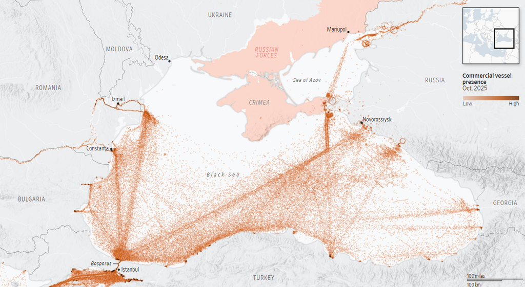
The expansion followed the spread of targeting beyond the legacy area. In the 12 months to 21 September 2026, Ambrey recorded 45 merchant vessels struck outside the previously listed area, against none in the preceding 12 months. Within the legacy area, strikes rose from an average of four a month in the fourth year of the war to 28 a month in the fifth year to date, which turned it into a target-poor environment as owners withdrew vessels.
Since 16 September, Ambrey has observed a significant increase in the number of vessels using the territorial waters of Türkiye, Bulgaria and Romania between the Bosphorus and the Romanian and Bulgarian ports. The routing lets owners avoid time in the Listed Area, with its notification and additional premium requirements, at the cost of added distance and navigational planning. It rests on the assumption that strikes, which have largely occurred outside the territorial waters of non-belligerent Black Sea states, will continue to do so.
Context
Security Threats and Navigational Hazards Along Black Sea Coastal Shipping Routes
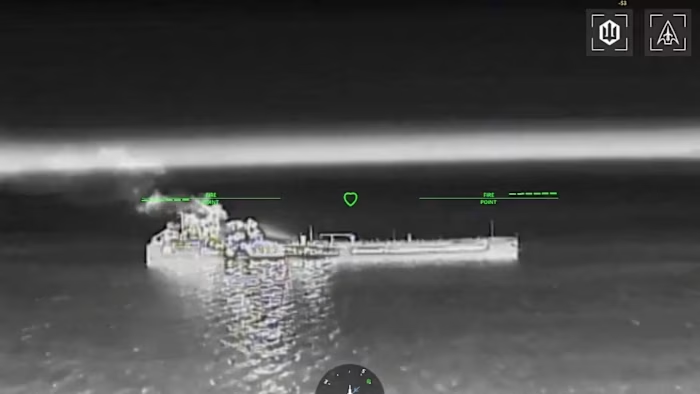
The protection offered by territorial waters is real but not reliable. A merchant vessel on a Chornomorsk to Istanbul voyage was struck 8.1NM south-east of Sulina on 30 July, within Romanian territorial waters. On 14 October a bulk carrier was struck 11.9NM south-east of Sulina, at the limit, and a tanker at Sulina Anchorage. On 6 October two merchant vessels were struck by UAVs and USVs in Bulgaria’s EEZ, about 70NM east of Byala, and on 13 October two more were struck in the same zone; one vessel sank on each date. On 23 October the KHORYV was struck about 13NM off Constanța, just outside the 12NM limit, and capsized; on 28 October the container ship CONTSHIP JET was sunk by USVs 24NM south-east of Kavarna, in Bulgaria’s EEZ. The Bulgarian Navy has also destroyed USVs that drifted out of control in its waters while still carrying explosives.
Bulgarian officials have said that, although Bulgaria was ready to deploy aircraft against the UAVs, it cannot legally take military action outside its territorial waters, and that its surveillance capability and naval presence in the wider EEZ are limited. This is an additional layer of threat: vessels hugging the territorial-sea limit sit beside waters in which strikes have occurred and in which the coastal state has stated it cannot respond.
Navigational hazard: GNSS jamming and AIS spoofing are persistent in the western Black Sea. The corridor is narrow, close to the coast and shared with fishing and leisure craft, some of which do not carry reliable AIS. A rise in commercial traffic in the same band, under GNSS and AIS interference, increases the likelihood of collision, grounding and close-quarters incidents, and reduces the time a bridge team has to distinguish a UAV, USV or drifting object from ordinary traffic.
Coastal-state response. Territorial waters are not high seas. Foreign merchant vessels enjoy the right of innocent passage, not freedom of navigation; a coastal state may prevent passage it considers prejudicial to its security and may temporarily suspend passage in specified areas where essential for its security. Türkiye, Bulgaria and Romania have so far kept their waters open. Türkiye has begun delaying Straits transit permits for some vessels bound for Ukrainian and Russian ports, and the three states have increased coordination on surveillance and mine countermeasures. A casualty involving pollution or loss of life inside territorial waters would sharply raise the political cost of that openness. Should there be a serious incident, it is likely that the scrutiny and inspections by the authorities will be markedly increased.
Risk to Hull Underwriters
The Hidden Cost of Safer Shipping Routes: Unpriced Exposure and Escalating Threats
Key risk for hull underwriters: The territorial-water band sits outside the Listed Area but is now where a growing share of Black Sea tonnage spends its time. The exposure is therefore concentrating in the part of the basin where the JWC mechanism gives underwriters no notification, no additional premium and no indication of how many insured hulls are present.
Exposure by zone under JWLA-035:
- Unpriced exposure. A vessel that stays inside the territorial seas of Türkiye, Bulgaria, Romania and Georgia for the whole voyage can transit without triggering notification. Underwriters see tonnage when it enters the Listed Area, not when it queues, anchors or passes close to it
- Accumulation. Traffic is concentrated in a narrow band, at a small number of approaches and anchorages, in predictable positions and with long dwell times. A single event, whether a collision in the lane, a stray abandoned hull, UAV or USV, or a strike, can involve more than one insured hull
- Edge exposure. The edge of the Listed Area is the territorial-sea limit. Vessels routing close to the line sit within a few nautical miles of waters where targeting has occurred, and GNSS error, spoofing displacement or an avoidance manoeuvre can carry a vessel across it
- Attribution of loss. Where state-originated GNSS interference contributes to a collision or grounding, the allocation of the loss between marine and war perils may be contested, depending on policy wording, delaying settlement and complicating recovery
- Intervention risk. If a coastal state restricts or suspends passage, vessels are likely to be pushed back towards listed waters, delayed at the Straits or held at anchor, raising aggregation and dwell time at short notice
- Severity. Pollution or loss of life in territorial waters brings coastal-state jurisdiction, clean-up claims and political scrutiny, in an area outside the Listed Area
Ambrey assessment: JWLA-035 has changed where vessels sail more than it has changed where they are at risk. It is likely that vessels will continue to concentrate in the territorial waters of Türkiye, Bulgaria and Romania while the current Listed Area stands, because the exclusion removes the notification and premium triggers on that route. It is a realistic possibility that further merchant vessels will be struck in or immediately outside those waters, and a realistic possibility that a collision, grounding or close-quarters incident involving a merchant vessel will occur in the corridor in the next six months. Should a significant event occur in Bulgarian, Georgian, Romanian or Turkish waters, it is likely that the coastal states will review their current position on open transit and become more assertive in deciding which vessels may pass; measures aimed first at vessels trading with Russian or Ukrainian ports would be the most probable form.
Recommendations
Recommended Risk Mitigation Measures for Insurers and Maritime Operators
Ambrey assesses it would be prudent and proportionate for hull underwriters and brokers to:
- Treat the territorial-water band as an accumulation zone in aggregate modelling, rather than relying on Listed Area notifications to measure Black Sea exposure given that the vessels may be forced to depart the territorial waters due to adverse weather, military exercises or other impromptu exclusion zones
- Request routing information, and where possible track data, for vessels declaring territorial-water routing, and monitor time spent close to the 12NM line
- Clarify with the broker how policy wording allocates a loss between marine and war perils where GNSS interference contributes
- Stress-test scenarios in which a coastal state restricts or suspends passage, forcing vessels into listed waters or to hold at anchor
For owners, operators and charterers of vessels routing through the territorial waters, it would be prudent and proportionate to:
- Conduct dynamic voyage threat assessments that treat the territorial-water corridor as part of the high-risk voyage, not as a safe lane
- Navigate on the assumption that GNSS and AIS are unreliable: cross-check position by radar, visual bearings and ECDIS, and increase lookouts, particularly at night
- Balance distance from the 12NM line against traffic density, avoiding both hugging the boundary and drifting or anchoring in fixed positions for longer than necessary
- Ensure crew remain within the designated Safe Muster Point during UAV and missile attacks; the SMP should be located above the waterline, amidships and low in the superstructure
- Brief masters on possible coastal-state passage restrictions and confirm Straits transit permit status before departure
Ambrey provides voyage-specific threat assessments and monitoring of traffic concentrations along the western Black Sea corridor to support underwriting and risk-based decision-making.
Frequently Asked Questions
JWLA-035 is the Joint War Committee’s revised Black Sea Listed Area, introduced on 16 September 2026. It extends the Listed Area across the Black Sea while excluding the territorial waters of Türkiye, Bulgaria, Romania and Georgia. The change has encouraged commercial vessels to use coastal routes to minimise time spent in listed waters and avoid associated war-risk notification and additional premium requirements.
Territorial waters offer some protection but are not free from maritime security threats. Ambrey has recorded vessel strikes within or near Romanian territorial waters and in Bulgaria’s Exclusive Economic Zone (EEZ). Commercial vessels remain exposed to UAV and USV attacks, navigational interference, collisions and grounding risks, particularly along increasingly congested coastal routes.
JWLA-035 creates a potential accumulation of uninsured-for-war-premium exposure in territorial waters excluded from the Listed Area. Vessels remaining within these waters do not trigger the Listed Area’s notification and additional premium mechanisms. Consequently, hull underwriters may have limited visibility of vessel concentrations, aggregate exposure and emerging security risks, depending on individual policy arrangements.
GNSS interference can disrupt vessel positioning, while AIS spoofing can produce misleading vessel location or movement information. These disruptions increase navigational uncertainty, particularly in congested coastal waters. Ambrey recommends cross-checking vessel positions using radar, visual bearings and Electronic Chart Display and Information Systems (ECDIS), alongside enhanced bridge watchkeeping.
Yes. Coastal states may introduce restrictions or temporarily suspend passage in specified territorial waters where necessary for security. Ambrey assesses that a significant maritime incident involving casualties, pollution or vessel damage could prompt increased inspections, tighter transit controls or restrictions affecting vessels trading with Russian or Ukrainian ports.
Ambrey recommends treating the territorial-water corridor as an accumulation zone, requesting vessel routing and tracking information, monitoring exposure near the 12-nautical-mile boundary and reviewing policy wording concerning marine and war perils. Underwriters should also assess scenarios involving coastal-state restrictions, prolonged anchorage and unexpected diversions into listed waters.
Shipowners and operators should conduct voyage-specific threat assessments, monitor changing maritime security conditions and prepare for GNSS and AIS interference. Recommended precautions include enhanced navigation checks, appropriate safe muster procedures, careful route planning and confirmation of Straits transit requirements before departure.
Ambrey provides voyage-specific maritime threat assessments and monitors commercial vessel concentrations along the western Black Sea corridor. Its intelligence supports shipowners, operators, charterers, brokers and hull underwriters in identifying emerging threats, evaluating operational exposure and making informed risk-based decisions.